By Mabinty M. Kamara
The Meteorological Agency of Sierra Leone (MASL) has warned of more heavy rains in the next two months as the country braces up for one of the highest rain falls in many years.
MASL officials say so far the highest monthly rain fall recorded is 800 mm in July in Kenema, compared to 695.4 mm last year in Both.
Gabriel Kpaka, Deputy Director General at SLMA, told Politico that heavy downpours are expected in late August and September.
“In late August this year to early September we will be expecting a high amount of rain fall compared to last year and this will cause a flash flood”, he said, adding that all the other parts of the country recording high amount of rains will also experience flash floods.
SLMA is one of many institutions still struggling to function effectively after it was left almost totally dysfunctional thanks to the civil war. Its radar, which used to be at Tower Hill, has never recovered and the agency has all these years relied on other reporting models main based on international sources to make forecast.
A notable downside to the MASL’s current capacity is that it can only forecast the rains but not the intensity of the rain, and therefore it cannot precisely predict the chances of disasters like flooding or the areas susceptible to such disasters.
“Forecasting rain is the simplest in meteorology but to forecast disaster you need some equipment that can help you determine the amount of storm and other things,” said Kpaka.
Based on its data, the MASL says said the east and northern regions of the country are expected to experience the highest amount of rainfall, with the east taking the brunt. Kpaka said two places of particular concern are Kenema and Makeni.
According to SLMA’s figures, the east is currently receiving the highest amount of rainfall, and Kpaka said this is likely to remain so for the rest of the season.
But the Met official added that even though these two regions are expected to experience the highest amount of rains, they are not as vulnerable to flooding like Freetown is, and he based this on topographical differences, citing the capital city’s hilly nature and poor drainage system as a major contributing factor to its vulnerability.
“Risks and vulnerability of flood depends on the topography and landscape of the area,” he said.
“In Freetown we have hills and people build houses in flood prone areas. The poor drainage system is also a contributing factor. Though it won’t be a devastating one, but those in flood prone areas will be affected,” he added.
Kpaka hopes that the Freetown City Council (FCC)’s flood mitigation program, which entails the cleaning of gutters, will help reduce the chance of devastating flooding.
The FCC, since last year, has been embarking on a cleaning exercise targeting gutters in about 62 identified flood prone areas in the city. Towards the end of July Freetown Mayor, Yvonne Aki-Sawyer, signed a Le2billion funding agreement with the central government through for phase two of the project.
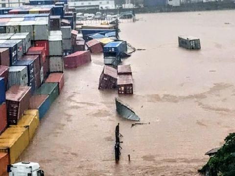
Sadly, in spite of all these efforts, parts of the city have already experienced flooding, as was tragically illustrated by the August 2 rain and flashfloods that claimed seven lives and destroyed millions worth of properties.
The MASL says that day’s rain is the heaviest single day rain in many years. It’s heavier than rain that led to the flood that partly caused the mudslide of August 14, 2018.
With a fully functional met office, disasters like this can be predicted and prevented with appropriate action taken. But Kpaka said that their forecast about the amount of rainfall is enough to get the people to know what’s about to happen and be prepared for it. He said they have always reported their forecast to the Office of National Security (ONS), whose mandate it is to evacuate people from disaster prone areas.
The Met office, fully aware of its limitations, has been trying to adapt and it’s using the resources at its disposal. This way Kpaka said they have put in place some flood mitigations and breakages by distributing five rain gages in strategic locations across the country, which are monitored by Red Cross volunteers who are also on standby in the event of a potential flooding.
“If it begins to rain and within a short period we record about 20mm of rains, that has a potential for flooding and so we will immediately call on the volunteers through mobile phone to be alert the community people to evacuate,” he explained. He said because of that the casualties in the August 2 flooding disaster were reduced
© 2019 Politico Online


